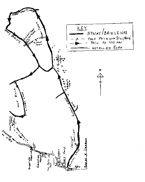
STARTING POINT - "George & Dragon" Potterne (Ref. ST995594)
This is a circular walk which can be shortened to a less strenuous walk when taking children.
The long walk being approximately 8 miles long.
The short walk being approximately 5 miles long.
Take the road opposite the George & Dragon (See Note-2) Coxhill Lane, pass the turning to the left at Woodbridge House and continue to follow Coxhill Lane which now becomes a byway (PP No.50), after about 130 metres you will pass Sugarwell Farm (See Note-1) on your right, your way now passes between steep wooded banks to a cross roads. Here the road to the right is also a byway - Stroud Hill (PP No.52) leading to the Urchfont road by Stroud Hill Farm, but we continue straight ahead until after about 170 meters you will have Grubbe's Wood on your right, this was once the property of the Grubbe family (See Note-6). Grubbe's Wood is immediately followed by Potterne Wood, shortly after the merging of the two woods (approximately 170 meters from their intersection) the byway (PP No.50) turns sharp Left.
You now have a choice of walks.
SHORT WALK
Continue to follow the byway to the left (PP No.50) which after a short distance inclines to the right to be joined on the left by Green Lane (PP No.51).
Turn left along Green Lane (See Note-8) and follow the route common to both walks.
Common to both walks.
Taking Green Lane (See Note-8) you will soon see in the distance three pine copse in a row to your left, these mark the course of your next path, continue along Green Lane (PP No.51) and after about 700 yards you will see on top of the left hand bank, by the first pine copse, a stile which gives access to a headland path (PP No.47), which follows the hedge on your right to pass the other two copse.
The fields to your right are shown on the map as "Nine Hills", however, older records show these fields were once known as "Lime Hills" (See Note-9).
Looking across these fields to your right you can see Roundway Hospital and a little to its left Drews Pond House in its woodland setting, the ponds themselves are not visible from here being hidden by the trees, these, there are three of them, were originally constructed to hold the water for working one of the six Potterne mills (See Note-10) recorded in the Doomsday Book, now they are managed by a retired farmer as a private wildfowl reserve.
Continue to follow path 47 to the last Pine Copse where it joins with a fenced path (PP No.51), turn right and follow this path (still PP no.47) between the hedgerows to Drews Pond Wood where the path turns lefthanded before dividing, one leg turning right into the wood (Roundway path No.17 leading to Devizes) whilst the other, our walk and Still PP No.47, incline's to the left and ascends into the open field, keeping the hedge close to your right, continue until by means of a stile you join the farm track by Montecello Farm where you turn lefthanded and follow in the tracks of the old "Limer's" for this is 'Limer's Lane' once used by the Limer's and their pack ponies from which it gets its name, follow this lane to its junction with the A360 Devizes Road opposite Sandfield Farm, taking care when crossing this busy main road turn left and follow this road (A360) back through the village to your starting point - The George & Dragon.
During your return journey you will pass the church of St. Mary The Virgin (See Note-11), built in the middle of the 13th century, there as been little change to the original structure apart from the addition of a South porch in the 14th century and the raising of the tower in the 15th. The font, dating from the early 15th century is not the original, an earlier 10th century font having been found beneath the nave floor in
1872.
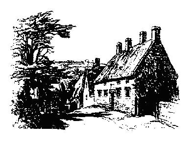
A little further on in the centre of the village is the nationally famous 15th. century Porch House.
Both the Church and Porch House are worthy of closer examination.
LONG WALK
At this point where the byway turns left, the bridleway (pp No.38 - Which we take for the long walk) continues in a North Easterly direction along side the wood with the field fence close on your left, after about 15 yards there is a Hunting Gate, through the Hunting Gate into the field and keeping the field fence close on your right, follow the bridleway to where by means of Hunting Gates it crosses a farm track at Sleight Farm. Cross the next field, again keeping the boundary fence close on your right to a Hunting Gate in the next field boundary, through this gate and cross the next field, but this time keeping the boundary fence close on your left.
On leaving this field turn left and follow the bridleway (This Bridleway is now in Stert Parish and is Stert Path No.11) to its junction with the metalled Stert Valley Lane (PP No.128), turning lefthanded follow Start Valley Lane (North Westerly) to its junction with Sleight Lane.
Turn left along Sleight Lane to Sleight Farm Cottages, here the road turns lefthanded and becomes a private road to Sleight Farm, the bridleway continues straight ahead and once again becomes a track, because this track is also used by agricultural vehicles it can get very muddy in wet weather. Follow this track (PP No.50) South-westerly for approximately 600 yards to where there is a byway turning to the right (PP No.51), take this byway and you will see in the near distance running to your left three pine copse the first of which marks your next turning point.
From this point follow the directions 'Common to both walks'.
Map for Walk 2