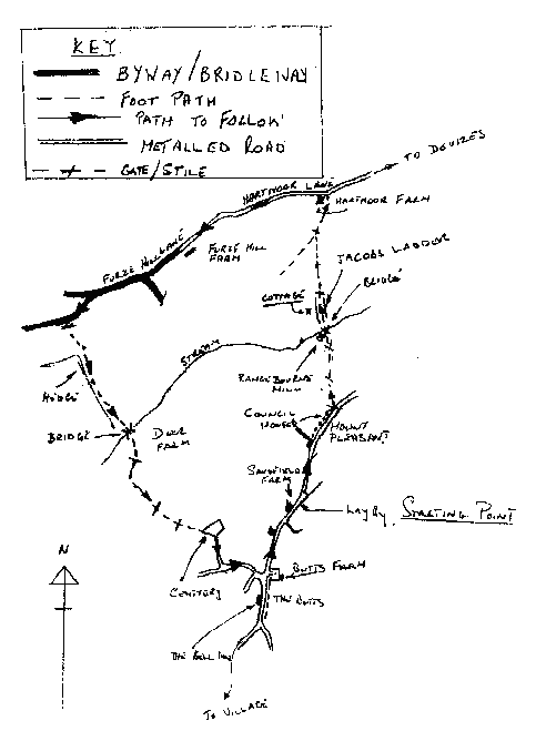
STARTING POINT - Sandfield Farm (Ref. ST998592)
This is a circular walk approximately 3½ miles.
Our starting point is Sandfield Farm north of the village of Potterne on the A360 Devizes to Salisbury Road. (Opposite the farm is a lay-by where a car may be parked)
Follow the main road (A360) towards Devizes until you come to the red brick council houses at Mount Pleasant, immediately after the last house is a field gate, wooden stile and sign post indicating your line of travel to 'Hartmoor', climbing the stile head north across the corner of the field (At approximately 45 degrees to the main road) to another stile in the opposite hedge, from here the path (PP No.74) continues across the field to a stile adjacent to Rangebourne Mill (See Note - 10).
The path passes in front of the mill, keeping its garden wall on your left follow the path round to the bridge over the mill stream, now landscaped, here the path climbs Jacobs Ladder, a steep path between tall hedges, reaching the top of the ladder a further stile takes you into a wide field where the path continues northwards towards a gate in the far fence shortly before reaching this gate you join a path (PP No.70) coming from your left, follow this path to the gate in the far fence, through this gate and the path heads towards Hartmoor Farm in the near distance here, to the left of the farm (Now a domestic residence) is a stile leading into Hartmoor Lane.
Hartmoor Lane was once the main highway from Devizes to Erlestoke and Edington via Five Lanes, always notorious for its muddy condition, when Hartmoor Lane was of greater importance than it is today Hartmoor Farm was the Angel Inn providing rest, refreshment and overnight accommodation for the weary traveller.
Reaching the metalled road by Hartmoor Farm turn lefthanded to the next farm - Furze Hill Farm - here the metalled road changes to a grassed byway which is also used by agricultural vehicles causing very deep ruts in wet weather so good boots are essential during the winter months.
About 550 yards past the farm is a tubular steel stile set in the left hand hedge, this leads into an 'L' shaped field, from here there is a good view across the valley to Potterne Church and the village, the footpath (PP No.76) crosses the open part of the field (The foot of the 'L') to follow the hedge (On the upward arm of the 'L') on you right to the bottom of the field, on reaching the stream at the bottom of the field you will see a wooden bridge, over the bridge the path (Now PP No. 75) inclines to the right between a tall wire fence on your left and a newly planted copse on your right, this is Potterne deer farm where deer may be seen in many of the adjoining paddocks.
Taking path No.75 a wooden stile leads into the next field where the path inclines left to cut the corner of the field to the end of the hedge now on your left, here the path again inclines left and heads for the field gate in the top hedge, through this gate keep the tall deer fence close on your left to a wooden stile at the top of the field by the gate, this stile takes you into a farm access road (PP No. 69) continue up this road with Potterne cemetery on your left, turn right by the cemetery gates into Brownleaze Lane which will take you to Blackberry Lane, turn left at Blackberry Lane to join the A360 Devizes road at the Butts so called because this area was used for archery practice in ancient times. A few yards to your right is the Bell Inn where refreshments may be purchased if you are so inclined, or turning left along the A360 will bring you back to your starting point at Sandfield Farm.
Map for Walk3
© 1993 Leslie. J. Turner