STARTING POINT - "George A Dragon" Potterne (Ref. 5T995594)
This is a circular walk of approximately 12 miles.
Take the road opposite the George & Dragon - Coxhill Lane - pass the turning to the left at Woodbridge House, continue to follow the byway straight ahead (Sleight Lane - PP No.50), as it passes through steep wooded banks you will see the pavilion of Potterne Cricket Club situated on top of the left bank..
After a little while you will come to a cross roads, continue straight ahead along Sleight Lane to pass Grubbe's Wood on your tight (See Note-6).
As Sleight Lane levels off at the top of the hill there is another bridleway turning off to the left, this is Broad Lane (PP No.45), taking this bridleway you now cross the top of Potterne Field (See Note-13), about half way along this path and you will see a young tree to your left, this is 'Potterne Little Tree' (See Note-10), continue along Broad Lane to where the bridleway (now fenced on both sides) turns lefthanded through 90 degrees, here the bridleway turning left becomes PP No. 46 for its return to the main road (A360), whilst PP No.45 continues straight ahead for a few metres as a footpath, soon it joins a footpath coming across the field from the right (PP No.47), path 45 ceases at this junction, the road ahead becoming PP No.41 which now descends between two hedgerows to a post and rail fence on the edge of Drews Wood where it turns sharp left following the post and rail fence for a few metres before climbing away to the right, at this point there is an opening in the fence to your right giving access to the wood.
Entering the wood through this gateless opening you will leave Potterne Parish and enter the Parish of Roundway, the path you are now following is Roundway Path No.17, this descends the steep hill through the wood where you should keep the boundary fence close to your right to reach the metalled road which is fenced as it passes Drews Pond.
These ponds once provided the motive power to run Drews Mill (See Note-10), the grounds are now tastefully landscaped and are a pleasure to see at all times of the year whilst the ponds are hose to a variety of wild fowl.
Follow the metalled road, Drews Pond Lane past the wood on the right which is a part of the grounds of Roundway Hospital, a new nature trail through these woods was opened in 1992 and is well worth a visit at a later date, continue to follow Drews Pond Lane up the hill, and past Downlands School and playing fields on your right to its junction with Downlands Road, continue to follow Downlands Road through the housing estate to its junction with Wick Lane at Wick Lane turn left and follow it to its junction with the main Potterne - Devizes road, the A360.
The A360 is a very busy road, so please cross it with care.
After crossing the A360 turn right towards Devizes for about 170 metres to where there is a footpath turning off to the left, this path is marked with a finger post informing you that its destination is Queens Road and Hillworth Park, follow this path to Queens Road and crossing Queens Road enter Hillworth Park by the tubular 'pass gate', this gives access to the 'working' part of the park, now follow the main path through the park towards the large white house ahead.
As you enter the park proper you will see and hear the birds in the aviary across the grass to your right, this is followed by an old brick and stone summerhouse to the left of which is a wrought iron gate leading to the pets cemetery and close to here are the public toilets.
Passing the children's play area on your left you now approach the big white house which has dominated the view ahead since entering the park, this is the big house, now subdivided into smaller properties of which the park was originally the garden, taking the path to the left of the house you emerge into Hillworth Road.
Crossing Hillworth Road take the road opposite, between the old peoples bungalows, from here you can look across the valley to a fine example of Norman architecture, St. Johns Church with the tower of St. Marys rising above and behind it.
Follow the path as it turns first to the left and then to the right before descending behind the castle grounds to rise again and by means of an old steel bridge cross all that remains of the once vital railway service to Devizes, a deserted cutting travelling for a few metres to your left before ending at a solid wall. This wall was erected to close Devizes tunnel the other end of which was Devizes station, the station is now a car park and the tunnel a rifle club, however, from the old bridge you get a very good view of the rear of Devizes castle. (See Note-18), cross the bridge and you enter St john's Church yard, the paved path now takes you past cottages of varying periods to your left, whilst a little way into the cemetery area on your right you will see a stone monolith erected by public subscription as a reminder of an accident that occurred in June 1751 and as a salutary warning to all who may read the inscription
"In memory of the sudden and awful end of Robert Merrit and Susannah, his wife, Eliza Tiley her sister, Martha Carter and Josiah Dereham, who were drowned in the flower of their youth in a Pond near this town called Drews, on Sunday evening, the 30th. June, 1751 and are together, underneath entombed.Soon a path turns off to the left through wrought iron gates into St. Johns Court, the building on your left was a medieval court from which this 'alley' gets its name whilst the house at the top of the alley on your right was once an inn, the Scribbling Horse.Remember the Sabbath Day to keep it holy."
Please Note.
From this point the walk follows the busy main road through Devizes but there is no need to cross this busy road unless you wish to further investigate the treasures of Devizes.
Passing the Town Hall on your right you now enter St. Johns Street where on your left is the Crown Centre, this houses the towns Information Centre as well as being a 'drop in' centre for the elderly of Devizes and district. Formally the Crown Inn dating back to 1538, on the stone pillar by the door is the reproduction of a sign showing the old coach stages to remind us of its former days as a coaching inn, across the road from the Crown Centre is the Cheltenham and Gloucester Building Society, this imposing building was built around 1750 and was Devizes Town Hall until 1836.
Leaving St. Johns Street you now enter the Market Place where a market has been held since the 13th. century, on your left as you enter is the Bear Hotel dating from 1599.
In 1773 a new landlord took over the Bear Hotel who was responsible for erecting poles over Salisbury plain to guide the weary traveller, later his son was to become famous as Sir Thomas Lawrence the portrait painter, some of who's early sketches now adorn the walls of the hotel. Above the entrance to the Bear Hotel is the statue of a bear which once surmounted a tall column in the market place, Devizes museum displays a painting of the Market Place dated 1804 showing the column and bear in its original position.
In the Market Place is the Market Cross, this was given to the town by Lord Sidmouth in 1814 and on the side of the cross is told the tale of Ruth Pearce of Potterne who was 'struck dead' in 1753 for telling a lie, next to the Market Cross is the Estcourt fountain which was erected by public subscription in 1879 as a tribute to T. H. Estcourt M.P. for Devizes and founder of the Wiltshire Friendly Society.
Now as you leave the Market Place you will see ahead of you the imposing building of Wadworth's Brewery, shortly after passing Wadworth's corner you will, on the left hand side of the road, come to 'Sandcliff' a Urge early 18th. century house which has for many years been a Doctors home and surgery, this is where George Elliot the novelist stayed when the house was occupied by Dr. Brabant in 1843.
Passing the end of Station Road and St. Joseph's Place you will come to steps leading down to the canal tow path (this is before reaching the Elf Garage), descend these steps and follow the tow path away from the main road.
The Kennet and Avon Canal was opened on the 28th. December 1810 for the transportation of goods, mostly coal from Bristol to Reading, after the second World War it was allowed to fall into decay until eventually the job of restoration was taken on by the Kennet and Avon Canal Trust, the final part of this gigantic task was the restoration of the flight of locks at Caen Hill, which were officially opened by Her Majesty Queen Elizabeth II on 8th. August 1990
NOTE: - Further information relating to all aspects of the canal are available from the Kennet and Avon Canal Trust office situated at the old Wharf which is easily reached from the Market Place by walking up Snuff Street (behind the fountain), from the Wharf it is possible to cross the canal to gain access to the towpath and rejoin the walk at the bridge by the Elf Garage.
The next bridge is known locally as Prison Bridge, Devizes Prison having been situated to the left of the towpath on the Devizes side of the bridge, the prison was opened in 1817 and remained in use until after the first World War being demolished in 1924, the bridge over the canal made a good vantage point for those wishing to watch executions taking place in the prison yard.
When passing under these bridges note the grooves worn into the stone pillars, these were caused over many years by the tow ropes from horse to barge chafing the stone as the horse once having passed under the bridge returned to the centre of the tow path, some bridges were fitted with vertical rollers at the corners of the stonework which turn as the rope passed over them thus preventing any wear.
Having passed under Prison Bridge the tow path now descends the famous Caen Hill flight of locks which were opened by Her Majesty the Queen after restoration by the Kennet & Avon Canal Trust.
Continue down the locks to the next bridge by Foxhangers Farm, having passed under the bridge we now leave the canal tow path to turn righthanded along the Rowde road, follow this road to its junction with the main A361 Devizes - Bath road.
This is another very busy road so care must be exercised when crossing, having crossed the A361 turn righthanded and take the first turning left sign posted to Poulshot, you now have a one mile walk along this road until you reach the village green where conveniently situated to provide rest and refreshment is the Raven Inn.
The last farm on your left before the Green is aptly named Higher Green Farm, pass the farm and take the bridleway which turns left to run by the farm wall, this is Hay Lane (Poulshot path No.5).
Continue to follow Hay Lane to were it turns 90 degrees to the right to pass through a lovely avenue of trees before reaching a small bridge with iron handrails which takes the path over the stream, this is an ideal place to take a rest, a leafy glade and a handrail to lean on whilst watching the ever changing face of the water as the two streams join to become one.
Across the fields to your left front, the old Manor House at Potterne can be seen through the distant trees, this is now Wiltshire Fire Brigade H.Q. with its tall radio mast standing like a giant obelisk against the sky, whilst across the meadows to the right the village of Poulshot lies peaceful in the distant haze.
Shortly after crossing the bridge there is a stile by a field gate on your left which gives access to a footpath (PP No.85) this path follows the stream to your left as far as 'By The Mill Farm' which can be seen in the distance, here the path crosses the metalled road to a wicket gate leading into the garden of Jenny Mill now Mill School. (See Note-l0)
This path crosses the vegetable garden of Mill School so please keep dogs and children under close control and confine your walking to on the grass path which leads to the steel farm gate opposite, from here the path climb's diagonally to the top of the embankment on you left to a wooden stile followed by a wooden bridge which puts the stream on your left and the old mill race on your right, cross the mill race to the wooden stile, then there are two more fields to cross and stiles to climb, still with the stream on your left.
The next stile is a little way into the field, and consists of two stiles and a crossing over a drainage ditch, to your left by the stream you will see tubular steel rails, these marks the outlet from the sewerage works, it is best to keep children away from this area.
From here the path inclines to the right to cross diagonally over the next two fields to a made up road, Field Lane (PP No.115).
Cross Field Lane to the gate opposite and immediately to the left of the old sewage works boundary hedge, entering the field and keeping the sewage works fence close on your right you now head for the gateway in the far hedgerow which is closed with two horizontal steel tubes, having negotiated this "Stile" cross the field (At approximately 30 degrees to the hedge on your left) to a gateway in the far hedge, through this gateway and again keeping the hedge close on your left, head for Parsonage Farm in the distance.
Take the second gate (the first giving access to a field) this leads into an area enclosed with barbed wire where hay and straw bales are often stored, leaving this enclosure by the gate in the left corner you will enter the farm yard proper, half incline left to the pass gate in the righthand corner of the yard next to the grey house.
Passing through the gate and over the small bridge you enter Lower Street by the Running Tap', this 'tap' was erected to provide fresh water for people living in the area, the water being piped from the original spring part way up the hill behind the house, it was from this spring that all their water had to be carried before the running tap was installed.
Leaving the running tap behind continue straight ahead to where a 'No Cycling' sign on the right indicates the start of a footpath (PP No.116), this path will take you through The Pitchings and into Mill Road at the bottom of which is Little Mill, now a private residence and another of Potterne's 'Six mills', entering Mill Road turn left to pass first Mill Road Chapel on your right closely followed by the Village Hall on your left, the red brick building on the right and situated on church corner at the top of Mill Lane, is now two private dwellings but was originally the Organ public house and was the origin of the conundrum 'Where would you find the organ placed outside the church ?' answer 'Potterne'.
Opposite the Village Hall and to the rear of the one time 'Organ' is a small path and steps leading down to Duck Street which in turn leads into the High Street passing the famous 15th century Porch House on your left from where it is but a short distance along the High Street to your starting point at The George and Dragon.
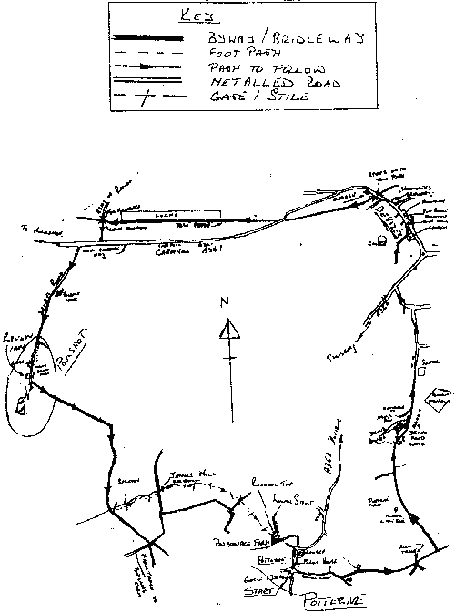
Map for Walk 6