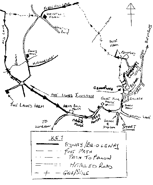
STARTING POINT - "George A Dragon" Potterne (Ref. 5T995594)
This is a circular walk of approximately 5 miles.
From the George and Dragon turn left to follow the High Street through the centre of the village to 'Church Corner', take the road straight ahead, Tollbar Lane leading to Lover Street and Whistley Road, follow the road to where it turns sharp left at the old red cottages, this is Crown Place so called because of 'The Crown' public house which used to be here, now take the footpath passing to the right of these cottages, this is the continuation of Tollbar Lane (PP No.67).
Follow this path as it winds its way behind the council houses to a point a little after a sharp right hand turn to where there is a footpath turning off to the left in actual fact this path going off to the left is still Tollbar Lane (PP No.67) the path continuing straight ahead is now Blackberry Lane (PP No.135) the original Blackberry Lane from which the housing estate gets its name.
Ignoring Blackberry Lane, take the turning to the left and continue to follow Tollbar Lane to where it enters Brownleaze Lane (PP No.69), turn left here and follow Brownleaze Lane to where it turns righthanded to the deer farm, at this point there is a wooden stile leading into the field ahead.
The path here (PP No.75) follows close to the tall deer fence on your right to a stile in the hedge at the bottom of the field.
From here the path inclines half right towards the hedge corner where it joins with PP No.76 approaching across the field from the right this path takes you round the corner of the hedge to a wooden stile about half way down the right hand hedge, over this stile and keeping the deer fence close on your right continue to the wooden bridge over the stream, this stream small as it may seem was once used to power Drew's Mill, Rangebourne Mill, Whistley Mill some times referred to as Snuff Mill, an indication of its later use, before passing on to power Jenny Hill.
The path now climbs the hill following the hedge on your left, at the top of the field where this hedge turns lefthanded the path continues ahead to the metal stile in the hedge ahead, giving access into Furze Hill Lane (PP No.84), turning left here continue to follow this byway which can be muddy in wet weather, however after a short distance there is a raised footpath which runs to the right of and parallel with the byway, this footpath will bring you out onto Whistley Road having passed through Whistley Farm.
Turn right along Whistley Road to the farm gate on your left, just after passing Mill Lane leading down to Jenny Mill now the Mill School, enter the field to the right of Mill Lane by means of the field gate, from here the path (PP No.105) cuts across the corner of the field at about 45 degrees to a wooden stile in the far hedge which gives access to the next field, here the path follows close to the left hand hedge. About two thirds of the way across this field the path inclines to the right and heads towards a wooden stile in the wire fence ahead in front of which is a small wooden bridge over a drainage ditch, crossing this bridge and stile the path leaves the parish of Potterne and enters the parish of Poulshot, at this point Potterne path number 107 becomes Poulshot path number 21, which after only a short distance crosses Hay Lane (Poulshot Path No.5).
Here our walk turns lefthanded to follow Hay Lane, a road used as a public path, to eventually cross the old brick bridge over the stream where you re-enter the parish of Potterne and Hay Lane becomes a bridleway (PP No.111).
Approximately 200 yards after crossing the bridge there is a stile on the right, here there is a choice of paths:-
- You may continue to follow the bridleway - Hay Lane (PP No.111) to Five Lanes Junction, or if this is very muddy as it often is in winter you may wish to use the footpath through the adjacent fields.
- The stile on the right gives access to a footpath (PP No.130) which follows close to the hedge and runs parallel to Hay Lane, rejoining it at the Five Lanes junction.(See Note-19)
In years gone by when the old Byways and Bridleways were the busy work roads of their day they often became almost impassable during winter months and so footpaths which followed the line of the Byway or Bridleway but keeping to the higher and drier ground of a neighbouring field were used by pedestrians, Potterne Path No.130 is just such a path.
At the Five Lanes junction you take the second opening to your left, Pound Hill (PP No.l08)(See Note-5), here again you have a choice of paths you can continue along the bridleway (PP No.108) to Abbotts Ball Farm or you can once again take the field path (PP No.131) which this time follows to the left of the bridleway, access to this path is gained by using the stile at Five Lanes junction situated by the field gate on the left hand side of Pound Hill, this path rejoins bridleway No.108 at Abbotts Ball Farm (See Note-3). Reaching Abbotts Ball Farm you turn left to follow the main Potterne to Worton road passing the old Manor House now the head quarters of Wiltshire Fire Brigade on your right, continue to follow this road to pass Court Hill house on your left where the road turns righthanded and starts its descent of Court Hill to return you to your starting point at the George and Dragon.
Map for Walk 7